Vuzelle waterfall return
Planay Hiking itinerary
Route
:
Aller / Retour
Daily duration (minutes)
:
150
Distance (km)
:
4.6
Route
:
300
Level bue - easy

 Departure/Arrival
 Point of interest
Circuit n° 1
- Environment :
- Mountain location
Informations
- SITRA services :
- Route
- Route 1660
- Typologie promo SITRA :
- Not recommended in bad weather
- Parking :
- Car park
- SITRA services :
- Services
Informations
Vuzelle waterfall return
La Rochette
73350
Planay
Phone : +33 4 79 55 03 77
Presentation
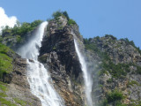
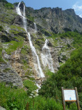
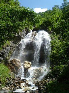
Nearly 600 feet high and listed as a heritage site since 1935, the Cascade de la Vuzelle dominates the valley: an amazing hike! Departure La Rochette
Outward route: to reach the starting point, take the path towards Le Mollard. When you reach the road, turn right and continue for 100 metres until you reach the hairpin bend. There, leave the road and join the marked trail.
At the trail junction, continue on your left, following the stream upstream to the footbridge. Continue towards the waterfall.
Pass below Pointe de la Vuzelle to reach the foot of the waterfall.
Highlights of the route:
Discover a majestic and wild setting at the foot of La Vuzelle, a listed Natural Heritage site. A waterfall just under 200 metres high.
Security
Take the weather forecast before leaving.
Don’t forget to drink to eat and have a break.
Equipment
Equip yourself with good shoes and clothes well suited for mountains.
Carry IGN map. This map is provided for information purposes only.
Good behaviour
Stay on track.
Respect the environment .
Be careful with herds, keep your dog on leash.
Be careful with your waste, bring it back with you.
OuverturesFrom 01/05 to 31/10 daily.
Depending on snow condition.
Depending on snow condition.
To know
Topos pas à pasDeparture: La Rochette
1/ To reach the departure point, take the path towards Le Mollard.
2/ When you reach the road, turn right and continue for 100 metres until you reach the hairpin bend. There, leave the road and join the marked trail.
3/ At the trail junction, continue on your left, following the stream upstream to the footbridge. Continue towards the waterfall.
4/ Pass below Pointe de la Vuzelle to reach the foot of the waterfall.
5/ Return route: same route
Alerte visiteursThis hike is accessible with a dog, but we advise you to keep your dog on a lead throughout the entire route. This helps to protect wildlife, preserve flora and ensure the peace and quiet of other hikers.
Pics
Pics


Linked offer
Course
Planay
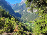
Classified in 1935, the Vuzelle waterfall is an outstanding element of the landscape of the valley of Planay, which is easy to see with the 3 peaks of...
Located at the start
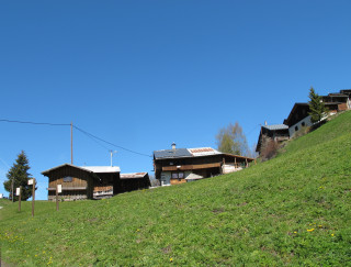
Planay
Located between the village and the alpine pasture, on the sunny side, “les montagnettes” are really small villages temporary inhabited according ...