Dent du Villard return (From le Planay)
Planay Hiking itinerary
Route
:
Aller / Retour
Daily duration (minutes)
:
390
Distance (km)
:
12
Route
:
1250
Level black - very hard

 Departure/Arrival
 Point of interest
Circuit n° 1
Car park close to the church
- Environment :
- Mountain location
Informations
- SITRA services :
- Route
- Route 2285
- Typologie promo SITRA :
- Not recommended in bad weather
- Parking :
- Car park
- SITRA services :
- Services
Download
Informations
Dent du Villard return (From le Planay)
Rue Saint-Grat
Parking de l'église
Planay
73350
Planay
Phone : +33 4 79 55 03 77
Presentation
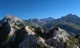
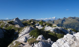
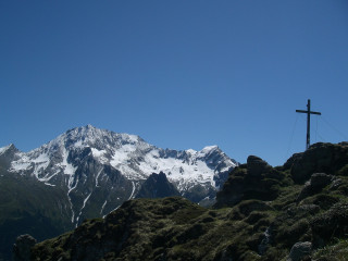
Start with the sound of the torrent in the forest, and discover at the top a stunning panorama and an outstanding geological place, straddling between Courchevel, le Planay and the Vanoise
Outward route: Cross over towards the church. On your right, take the path that runs alongside the houses and descend towards the stream to join the road below. Cross the stream and follow the markings opposite, towards Bonneval/Dent du Villard.
Take the forest path which, after crossing a stream, climbs in tight hairpin bends, offering brief views of the Grand Bec, the Vuzelle, the Planay and the peaks of the Vanoise massif.
At the fork, turn left towards Bonneval. Cross a large area of gypsum erosion cones before arriving at the ruins of the Bonneval summer chalets.
Continue towards Col de la Chal/Dent du Villard.
Return route: Return via the same route.
Highlights of the route:
Discover one of the valley's must-see peaks, with its many facets and gypsum massif that creates a unique landscape. Exceptional flora in the summer months.
Security
Take the weather forecast before leaving.
Don’t forget to drink to eat and have a break.
Equipment
Equip yourself with good shoes and clothes well suited for mountains.
Carry IGN map. This map is provided for information purposes only.
Good behaviour
Stay on track.
Respect the environment .
Be careful with herds, keep your dog on leash.
Be careful with your waste, bring it back with you.
OuverturesFrom 15/05 to 15/10 daily.
Depending on snow condition.
Depending on snow condition.
To know
Topos pas à pasDeparture: Planay
1/ Cross towards the church.
2/ On your right, take the path that runs alongside the houses and descend towards the stream to reach the road below.
3/ Cross the stream and follow the markings opposite, towards Bonneval/Dent du Villard.
4/ Take the forest path which, after crossing a stream, climbs in tight hairpin bends.
5/ At the fork, go left towards Bonneval. Cross a large area of gypsum erosion cones before arriving at the ruins of the Bonneval summer chalets.
6/ Continue towards Col de la Chal/Dent du Villard.
7/ Return route: Return via the same path.
Alerte visiteursThis hike is accessible with a dog, but we advise you to keep your dog on a lead throughout the entire route. This helps to protect wildlife, preserve flora and ensure the peace and quiet of other hikers.
Pics
Pics


Linked offer

Planay
Le Planay Chef-lieu (1130 m) is quite typical by the way of how it is built: with houses on both sides of the road that leads to Pralognan la ...
Bozel
La Dent du Villard is a peak that offers a beautiful panorama of the Vanoise massifs, Mont Blanc and the surrounding peaks. This summit is original ...