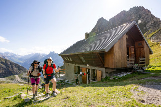
Grand Bec refuge loop (From Fontaine Froide)
Planay Hiking itinerary
Route
:
BOUCLE
Daily duration (minutes)
:
300
Distance (km)
:
8.3
Route
:
800
Level black - very hard

 Departure/Arrival
 Point of interest
Circuit n° 1
On the road towards Pralognan la Vanoise, take the road to Chambéranger, on the left going up after the village of Planay, and on the right going down from Pralognan la Vanoise.
Once in Chambéranger, take the mountain road towards Plan Fournier. Once in Plan Fournier, follow the signs (yellow signs) towards the Refuge du Grand Bec.
Once in Chambéranger, take the mountain road towards Plan Fournier. Once in Plan Fournier, follow the signs (yellow signs) towards the Refuge du Grand Bec.
- Environment :
- Mountain location
Informations
- SITRA services :
- Route
- Route 2405
- Typologie promo SITRA :
- Not recommended in bad weather
- Parking :
- Car park
- SITRA services :
- Services
Equipments & Services
- Passages delicats :
- En juin certains ruisseaux et/ou névés peuvent être délicats à traverser en raison de la fonte des neiges, n'hésitez pas à vous renseigner au préalable auprès de la gardienne.
Download
Informations
Grand Bec refuge loop (From Fontaine Froide)
Route de Plan Fournier
Parking de Plan Fournier
73350
Planay
Phone : +33 4 79 55 03 77
Presentation
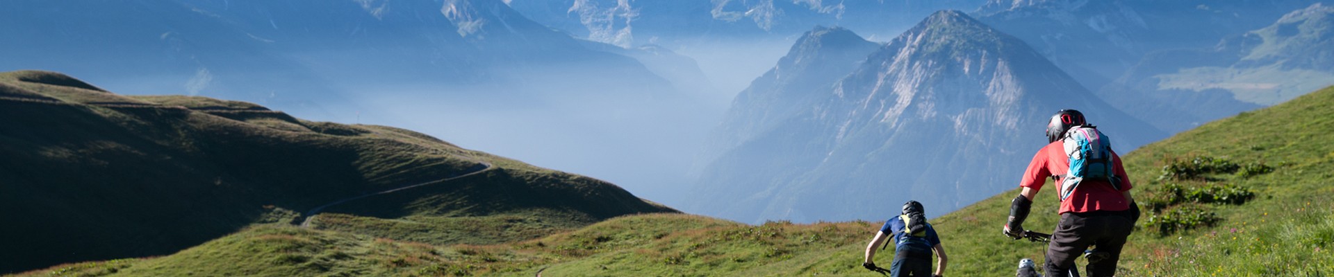
Definitively the Lord of the valley ! Perfect trail to discover landscapes and alpine pastures way of life. Take a break and enjoy a night at Grand Bec refuge. For mountain beginners, return trip to the refuge.
Yes, it takes energy to climb up to the Refuge du Grand Bec... but what a sight!
At dawn, the sun pierces the forest with its sparkling rays, as if to guide you along the right path. You will be crossing the aptly named Bois de l'Ours (Bear Forest), near Combe Louve... so keep your eyes peeled!
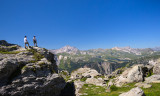
Very soon, the mountain pastures come into view, along with the beautiful peaks of La Vanoise National Park. You're sure to come across a few ibex and marmots along the way.
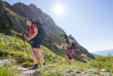
And take a closer look at the beautiful mountain flowers on the ground: the yellow of the arnica, the distinctive pink of the little soldanella, and the deep purple of the alpine gentian!
You'll find these colours again in the steaming dishes prepared by Agnès, who, with her southern accent, will treat you to a feast.
Come on, let's fill our water bottles at the fountain because the descent awaits us... and the return to civilisation too!
***
Outward route: From the Plan Fournier signpost (1,723 m), head towards Refuge du Grand Bec, following the marked trail throughout. Cross through the forest before climbing up the valley below La Vuzelle towards the pass of the same name to reach Refuge du Grand Bec (2,403 m).
Return route: Experienced hikers: From the refuge, turn right at the foot of Grand Bec and follow the signs for Fontaine Froide. Pass at the foot of the former Glacier de la Culaz and Grand Bec, crossing several mountain streams. At the fork, leave the Col des Gallinettes path continuing to the right and take the path on the left towards Plan Fournier. This will take you to the small chalet at a place called La Cave and then to the Fontaine Froide mountain pastures. The forest path joins Plan Fournier below.
Highlights of the route:
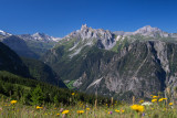
Ascent with breathtaking views of the Bozel Valley, Courchevel, the Lauzière massif and the peaks of the Vanoise. Alternative route with balcony trail and alpine atmosphere.
NB: In June, some streams and/or snowfields may be difficult to cross due to snowmelt. Please check with the caretaker of the Grand Bec Refuge beforehand.
At dawn, the sun pierces the forest with its sparkling rays, as if to guide you along the right path. You will be crossing the aptly named Bois de l'Ours (Bear Forest), near Combe Louve... so keep your eyes peeled!
Very soon, the mountain pastures come into view, along with the beautiful peaks of La Vanoise National Park. You're sure to come across a few ibex and marmots along the way.
And take a closer look at the beautiful mountain flowers on the ground: the yellow of the arnica, the distinctive pink of the little soldanella, and the deep purple of the alpine gentian!
You'll find these colours again in the steaming dishes prepared by Agnès, who, with her southern accent, will treat you to a feast.
Come on, let's fill our water bottles at the fountain because the descent awaits us... and the return to civilisation too!
***
Outward route: From the Plan Fournier signpost (1,723 m), head towards Refuge du Grand Bec, following the marked trail throughout. Cross through the forest before climbing up the valley below La Vuzelle towards the pass of the same name to reach Refuge du Grand Bec (2,403 m).
Return route: Experienced hikers: From the refuge, turn right at the foot of Grand Bec and follow the signs for Fontaine Froide. Pass at the foot of the former Glacier de la Culaz and Grand Bec, crossing several mountain streams. At the fork, leave the Col des Gallinettes path continuing to the right and take the path on the left towards Plan Fournier. This will take you to the small chalet at a place called La Cave and then to the Fontaine Froide mountain pastures. The forest path joins Plan Fournier below.
Highlights of the route:
Ascent with breathtaking views of the Bozel Valley, Courchevel, the Lauzière massif and the peaks of the Vanoise. Alternative route with balcony trail and alpine atmosphere.
NB: In June, some streams and/or snowfields may be difficult to cross due to snowmelt. Please check with the caretaker of the Grand Bec Refuge beforehand.
Security
Take the weather forecast before leaving.
Don’t forget to drink to eat and have a break.
Equipment
Equip yourself with good shoes and clothes well suited for mountains.
Carry IGN map. This map is provided for information purposes only.
Good behaviour
Stay on track.
Respect the environment .
Be careful with herds, keep your dog on leash.
Be careful with your waste, bring it back with you.
OuverturesFrom 15/06 to 30/09 daily.
Depending on snow condition
Please note that outside this period, the footbridge on the route is dismantled.
Depending on snow condition
Please note that outside this period, the footbridge on the route is dismantled.
To know
Topos pas à pas0/ Plan Fournier 1,723 m
1/ At the crossroads, take the path on the right 1,750 m
2/ At the crossroads, take the path on the right 1,812 m
3/ Continue along the path on the mountainside 1,850 m
4/ Take the path that climbs to the left 1,950 m
5/ Grand Bec refuge 2403 m
6/ Take the path on the right along the mountainside 2390 m
7/ Follow the path that descends to the left 2390 m
8/ Continue along the path that descends 2330 m
9/ At the crossroads, take the path on the right (Plan Fournier above) 2970 m
Alerte visiteursThis hike is accessible with a dog, but we advise you to keep your dog on a lead throughout the entire route. This helps to protect wildlife, preserve flora and ensure the peace and quiet of other hikers.
Pics
Pics

 - Planay - © Elisabeth Gayard")
 - Planay - © Elisabeth Gayard")

 - Planay - © Elisabeth Gayard")
 - Planay - © Geoffrey Vabre")
 - Planay - © Geoffrey Vabre")
 - Planay - © Geoffrey Vabre")
 - Planay - © Geoffrey Vabre")
Linked offer
Useful address
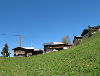
Planay
Back to basics: a warm and friendly, rustic, and peaceful atmosphere. Easy access: breathtaking views of the surrounding valleys, magical sunsets, and...
Planay
Located between the village and the alpine pasture, on the sunny side, “les montagnettes” are really small villages temporary inhabited according ...