Mont Jovet loop
Bozel Hiking itinerary
Route
:
BOUCLE
Daily duration (minutes)
:
390
Distance (km)
:
13
Route
:
1030
Level red ? hard

 Departure/Arrival
 Point of interest
Circuit n° 1
- Environment :
- Mountain location
Informations
- SITRA services :
- Route
- Route 2558
- Parking :
- Car park
- SITRA services :
- Services
Download
Informations
Mont Jovet loop
Route de la Cour
73350
Bozel
Phone : +33 4 79 55 03 77
Presentation
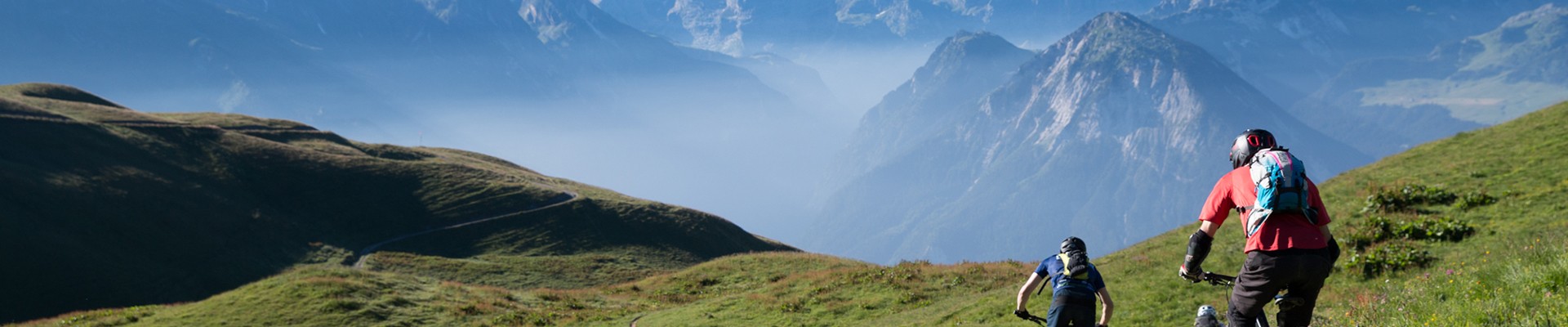
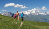
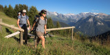
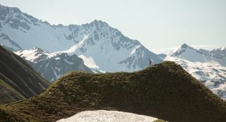
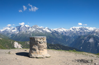
This route gives you a beautiful 360° panoramic view when the weather is good. You can see the Mont Blanc, the Vanoise, the Cervin, the Ecrins...
You have got a refuge on the route if you want to eat something.
You have got a refuge on the route if you want to eat something.
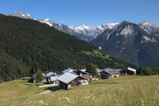
Start: At the first roundabout in Bozel, take the direction of Villemartin. Follow the road after Villemartin in the direction of La Cour, you can park your car at the end of the village. You have got two different paths to go to the Mont Jovet.
Either through the Bois de la Cour:
The path starts from the heart of the village. The path is quite nice within the forest. You have to follow the direction of la Grande Roche. You can follow the signs to the Mont Jovet.
Go back from the Bois des Perrières to make a loop.
Or through the Bois des Perrières:
You have to keep going after the village of la Cour until the river where you can park your car. Take the path on the left side of the river. The path which is going through the forest is quite steep. Follow the direction of the Mont Jovet.
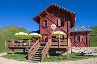
When you are at the refuge (2349m), follow the path to the Mont Jovet which allows you to go at the top (2558m). You will find there a beautiful view.
If you want, you can have access to the refuge through a carriage way that starts from la Cour.
The refuge of the Mont Jovet is open from mid-June to mid-September. Information: +33(0) 6 20 71 86 25.
This walk is medium, there are no big difficulties.
Either through the Bois de la Cour:
The path starts from the heart of the village. The path is quite nice within the forest. You have to follow the direction of la Grande Roche. You can follow the signs to the Mont Jovet.
Go back from the Bois des Perrières to make a loop.
Or through the Bois des Perrières:
You have to keep going after the village of la Cour until the river where you can park your car. Take the path on the left side of the river. The path which is going through the forest is quite steep. Follow the direction of the Mont Jovet.
When you are at the refuge (2349m), follow the path to the Mont Jovet which allows you to go at the top (2558m). You will find there a beautiful view.
If you want, you can have access to the refuge through a carriage way that starts from la Cour.
The refuge of the Mont Jovet is open from mid-June to mid-September. Information: +33(0) 6 20 71 86 25.
This walk is medium, there are no big difficulties.
Security
Take the weather forecast before leaving.
Don’t forget to drink to eat and have a break.
Equipment
Equip yourself with good shoes and clothes well suited for mountains.
Carry IGN map. This map is provided for information purposes only.
Good behaviour
Stay on track.
Respect the environment .
Be careful with herds, keep your dog on leash.
Be careful with your waste, bring it back with you.
OuverturesFrom 01/06 to 31/10 daily.
Depending on snow conditions.
Depending on snow conditions.
To know
Topos pas à pasStart: La Cour 1,527 m
1/ Turn right and take the forest track for a few metres 1,600 m
2/ At the crossroads, cross the forest track and continue straight ahead 1,771 m
3/ Continue straight ahead on the path (Grande Roche viewpoint on the left) 1938 m
4/ At the junction with the track leading up to the Mont Jovet refuge, turn right to rejoin the path a few metres further on. 2,280 m
5/ Mont Jovet refuge: continue along the path that climbs to the right behind the refuge 2,348 m
6/ Take the path that climbs to the right 2,420 m
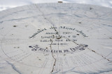
7/ Mont Jovet 2,558 m
8/ Take the path that descends to the left 2310 m
9/ Turn left at the junction with the track and follow it for a few metres 2250 m
10/ Take the path under the track, on the right 2250 m
11/ Arrival at the Grand Rey farm, take the track for about a hundred metres 2050 m
12/ Take the path under the track on the right 2040 m
13/ Take the path downhill on the right 1910 m
14/ When you reach the road, turn right and follow the road downhill to the starting point. 1582 m
1/ Turn right and take the forest track for a few metres 1,600 m
2/ At the crossroads, cross the forest track and continue straight ahead 1,771 m
3/ Continue straight ahead on the path (Grande Roche viewpoint on the left) 1938 m
4/ At the junction with the track leading up to the Mont Jovet refuge, turn right to rejoin the path a few metres further on. 2,280 m
5/ Mont Jovet refuge: continue along the path that climbs to the right behind the refuge 2,348 m
6/ Take the path that climbs to the right 2,420 m
7/ Mont Jovet 2,558 m
8/ Take the path that descends to the left 2310 m
9/ Turn left at the junction with the track and follow it for a few metres 2250 m
10/ Take the path under the track, on the right 2250 m
11/ Arrival at the Grand Rey farm, take the track for about a hundred metres 2050 m
12/ Take the path under the track on the right 2040 m
13/ Take the path downhill on the right 1910 m
14/ When you reach the road, turn right and follow the road downhill to the starting point. 1582 m
Alerte visiteursWe advise you to keep your dog on a leash due to the presence of livestock and in order to protect wildlife.
Interactive map to locate guard dogs in Savoie: https://www.pasto-kezako.fr/mappatou/
Interactive map to locate guard dogs in Savoie: https://www.pasto-kezako.fr/mappatou/
Pics
Pics


Linked offer
Located at the start
Bozel
Located at 8 km from Bozel, the hamlet of la Cour is easy to reach only in summer. In winter, the road is closed from Villemartin.
Useful address
Bozel
Come and enjoy the breathtaking panorama from the recently restored Mont Jovet refuge.
Guarded in summer, it is ideal for a discovery with family, ...
Course
14 June(every year)
from 08:00
8am: Mont Jovet Ridge Trail – 30km – 2,200m elevation gain
9am: Woods Trail – 22km – 1,350m...
Bozel
The panorama offers a view of the Ecrins as well as the Cervin, with the Mont Blanc and the Vanoise domes in the foreground. Enjoy the autentic ...