Big rock climb : Eau de Mai - Pointe de la Vuzelle (face Nord)


Presentation
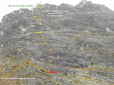
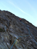
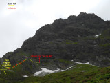
Mountain track on a developed length of about 300m.
Access: 15 min before arrival at the Grand Bec refuge and about 50 min from the terminal parking lot of Plan Fournier
Access: 15 min before arrival at the Grand Bec refuge and about 50 min from the terminal parking lot of Plan Fournier
Activities: Mountain Rock (Great Way)
• Difficulty onset altitude: 2220m
• Configuration: Face
• Main Orientation: North
• Type of route: loop / return to track or refuge
• Course time: 4 hours
• Overall rating: D
• Commitment: II
• Objective Risks: X2
• Quality of equipment in place: P1
• Rock Exposure: E2
• Free listing > oblig.: 5a+ > 4cA0
L1 5b < 5a
L2 5b with 1 step of 5c (to see!)
L3 4b - 5a - 4a
L4 4a
L5 3b max
L6 easy path
L7 5a with 1 step 5b
L8 easy path
L9 4a - 4b
L10 3c - 4a
L11 3b max
L12 4b - 5a
Exit of the track at the level of the first cross side of refuge.
Descent : Walking at best in the side side hut of the gd Bec between grassy slopes and some projecting rocks. About 30 minutes or so.
Remarks:
• 12 lengths from 20 to 30m.
• Relay with 2 points.
• Climbing courses taking place on quartzite rock (alas with sometimes vegetation, typical in Vanoise...)
This path is nevertheless to be avoided after heavy rains. In these conditions, it is better to wait for the rock to dry.
• Some easy passages pass through small grassy or scree vessels.
• Other good climbing passes should be cleaned up as you climb.
• In some places, the rock needs attention!....
• Track fully equipped with 10 or 8 ankle alternation + platelets.
Material:
• Minimum 12 delusions.
• A few straps to avoid pulling the rope.
• Free carabiners, 50m fastening rope.
History of the itinerary:
Path opened between automn 2013 and July 2015 by Jean-Marc Granger and David Chevassu.
OuverturesFrom 01/06 to 31/10.
Spring to autumn, according to snow conditions and on your onw responsabilities.
Spring to autumn, according to snow conditions and on your onw responsabilities.
Informations
- Levels of sporting experience :
- For experts / practiced
- Sections :
- Sport
- Climbing sports :
- Rock climbing site
- Climbing sports
Informations
Big rock climb : Eau de Mai - Pointe de la Vuzelle (face Nord)
73350
Planay
Phone : +33 4 79 55 03 77
- Reception :


Destination
Escalade : Grande voie : Eau de Mai - Pointe de la Vuzelle (face Nord)
73350
Planay
GPS coordinates
Latitude : 45.41573
Longitude : 6.727932
- Environment :
- Mountain location
- Isolated
Prices
Free access.