Big rock climb : Le Grand Bec - Voie Granger (West face)


Presentation
High mountain race of about 20 lengths on a developed 1000m with a technical level, track listed in the set AD+ but requiring good physical resistance in view of its length and engagement.
• Activities: High Mountain Rock
• Altitude min / max: 1700m / 3240m
• Elevation: +1540m
• Altitude at beginning of difficulties: 2600m
• Elevation of difficulty : 640m
• Elevation of approach: 900m
• Configuration: ridge, summit
• Main Orientation: W
• Type of route: loop / return to track or at the refuge
• Course time: 1 day
• Overall rating: AD+
• Engagement: II
• Objective Risks: X2
• Quality of equipment on site : P2+
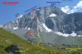
Le Grand Bec 3398m - Refuge du Grand Bec 2405m
Chambéranger - Plan Fournier/ Parking: 1700m
Vanoise - Savoie - France
IGN 3534OT Les Trois Vallées - Modane - Vanoise National Park
Approach :
To get to the Granger lane, from Plan Fournier (1700m) towards La Cave, Fontaine Froide, or through the refuge of the Grand Bec. The track begins at 50m from the lowest point of the S edge.
Ascension :
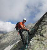
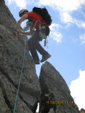
The route follows the ridge to remain all the length in the rock by avoiding some easy parts type fallen rocks and which could serve as escape.
12 lengthes between 30 and 50m of level 2 to 5b lead to an abseiling of 25m.
The 2 lengthes (50 and 20m) before the abseiling are quite sustainded but well equipped (peaks, plaques). At the foot of the abseiling, go back up to a small corridor of 20m leading to a small pass (2995m approximately). The way continues on a 4 lengthes equipped spaced out until approximately 3100m.
It is possible then to cross on the left to join the ridge N or to continue on approximately 200m straight by following the rocky difficulties of the edge which leads towards a monolith in the direction of the summit via the ridge N (see existing rundown). Anticipate protection in this case (straighteners, straps and possibly pitons).
Descent :
At the exit of the itinerary, several possibilities:
• Descend the N ridge to 3140m and then descend a steep hallway (40°) leading to the morraine on Froide Fountain side. Then reach Plan Fournier by La Cave
Overall running time: approximately 8h.
• Merge onto the top by the north ridge. Cross through the ridge leading to the Pointe du Vallonnet. Descend the glacier de la Vuzelle to reach the refuge of Grand Bec and Plan Fournier.
• From the top reach the Plan des gouilles by the glacier of Troquérou.
Remarks:
After the abseiling and a climb of 20m, at the small pass (2995m), an escape is possible by a succession of abseilings of 25m or a de-escalation.
This makes it possible to reach the moraine of the old glacier of the Grand Bec.
Four platelets in place.
Material:
• Glacier safety equipment if descent on Troquerou Glacier or Vuzelle Glacier
• Sectioners, straps, possibly a few pitons to complete the existing protections and parts not equipped.
• For descent by Troquérou or Glacier de la Vuzelle: spike piolet.
• If descent directly through the ridge N, depending on the season and persistent snow, spikes and piolet are required.
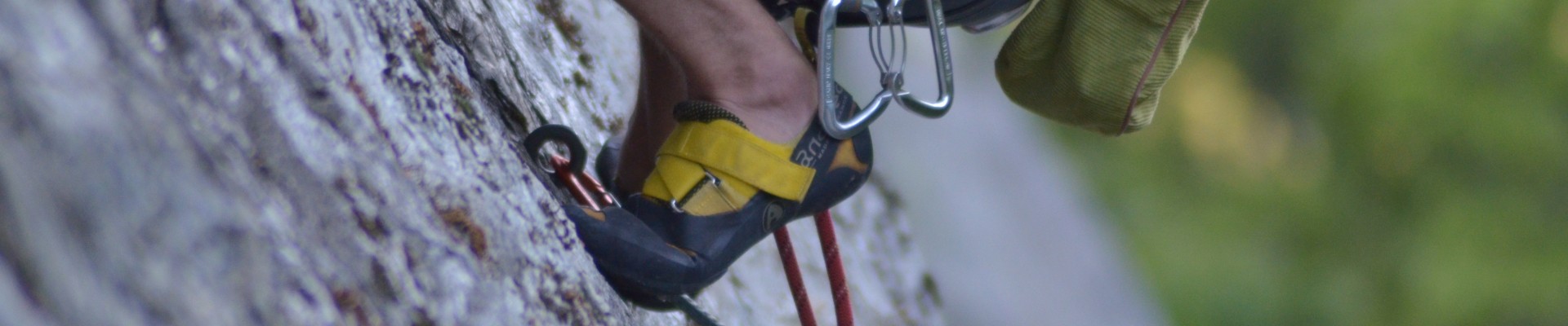
• In all cases, mountaineering shoes are preferred. climbing shoes are not required.
• 50m single rope
History of the itinerary:
Opening and equipping the itinerary in autumn 2013 and June 2014 by Jean-Marc Granger and David Chevassu with the help of Marie-Ange Tatoud Granger.
• Altitude min / max: 1700m / 3240m
• Elevation: +1540m
• Altitude at beginning of difficulties: 2600m
• Elevation of difficulty : 640m
• Elevation of approach: 900m
• Configuration: ridge, summit
• Main Orientation: W
• Type of route: loop / return to track or at the refuge
• Course time: 1 day
• Overall rating: AD+
• Engagement: II
• Objective Risks: X2
• Quality of equipment on site : P2+
Le Grand Bec 3398m - Refuge du Grand Bec 2405m
Chambéranger - Plan Fournier/ Parking: 1700m
Vanoise - Savoie - France
IGN 3534OT Les Trois Vallées - Modane - Vanoise National Park
Approach :
To get to the Granger lane, from Plan Fournier (1700m) towards La Cave, Fontaine Froide, or through the refuge of the Grand Bec. The track begins at 50m from the lowest point of the S edge.
Ascension :
The route follows the ridge to remain all the length in the rock by avoiding some easy parts type fallen rocks and which could serve as escape.
12 lengthes between 30 and 50m of level 2 to 5b lead to an abseiling of 25m.
The 2 lengthes (50 and 20m) before the abseiling are quite sustainded but well equipped (peaks, plaques). At the foot of the abseiling, go back up to a small corridor of 20m leading to a small pass (2995m approximately). The way continues on a 4 lengthes equipped spaced out until approximately 3100m.
It is possible then to cross on the left to join the ridge N or to continue on approximately 200m straight by following the rocky difficulties of the edge which leads towards a monolith in the direction of the summit via the ridge N (see existing rundown). Anticipate protection in this case (straighteners, straps and possibly pitons).
Descent :
At the exit of the itinerary, several possibilities:
• Descend the N ridge to 3140m and then descend a steep hallway (40°) leading to the morraine on Froide Fountain side. Then reach Plan Fournier by La Cave
Overall running time: approximately 8h.
• Merge onto the top by the north ridge. Cross through the ridge leading to the Pointe du Vallonnet. Descend the glacier de la Vuzelle to reach the refuge of Grand Bec and Plan Fournier.
• From the top reach the Plan des gouilles by the glacier of Troquérou.
Remarks:
After the abseiling and a climb of 20m, at the small pass (2995m), an escape is possible by a succession of abseilings of 25m or a de-escalation.
This makes it possible to reach the moraine of the old glacier of the Grand Bec.
Four platelets in place.
Material:
• Glacier safety equipment if descent on Troquerou Glacier or Vuzelle Glacier
• Sectioners, straps, possibly a few pitons to complete the existing protections and parts not equipped.
• For descent by Troquérou or Glacier de la Vuzelle: spike piolet.
• If descent directly through the ridge N, depending on the season and persistent snow, spikes and piolet are required.
• In all cases, mountaineering shoes are preferred. climbing shoes are not required.
• 50m single rope
History of the itinerary:
Opening and equipping the itinerary in autumn 2013 and June 2014 by Jean-Marc Granger and David Chevassu with the help of Marie-Ange Tatoud Granger.
OuverturesFrom 01/06 to 31/10.
Spring to autumn, according to snow conditions and on your onw responsabilities.
Spring to autumn, according to snow conditions and on your onw responsabilities.
Informations
- Levels of sporting experience :
- For experts / practiced
- Sections :
- Sport
- Climbing sports :
- Rock climbing site
- Climbing sports
Informations
Big rock climb : Le Grand Bec - Voie Granger (West face)
73350
Planay
Phone : +33 4 79 55 03 77
- Reception :


Destination
Escalade : Grande voie : Le Grand Bec - Voie Granger (versant Ouest)
73350
Planay
GPS coordinates
Latitude : 45.423527
Longitude : 6.752919
- Environment :
- Mountain location
- Isolated
Prices
Free access.