Big rock climb : Les Galinettes


Presentation
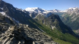
Nice panoramic setting next to the Grand Bec and nice walking approach. Beautiful alpine meadow with many water points.
Pointe de Méribel 2833 m Chambéranger - Plan Fournier parking 1700 m
• Activities: Mountain Rock
• Altitude min / max: 1700m / 2830m
• Difficulty start altitude: 2550m
• Elevation of approach: 850m
• Configuration: face
• Main Orientation: S
• Type of route: loop / return to track
• Course time: 1 day
• Overall rating: AD-
• Commitment: I
• Quality of equipment on site: P2+ Free listing: 5b > 4c.
Vanoise Savoie France Savoie: IGN 3534OT Les Trois Vallées - Modane - Parc National de la Vanoise.
Approach:
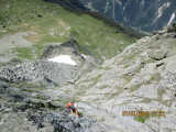
Departure from Plan Fournier 1700m. Direction Fontaine Froide by La Cave (about 1h). Around 2300m (cairn), reach on the left the Obvious Ridge line in the direction of face S. From this point, count about 30 min to reach the start of the way. Obvius starts on a kind of pillar, platelets, cords... Very beautiful alpine meadow with many water points. Pleasant bivouac, possible. The area is really nice and beautiful....
The way :
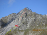
A way of 5-lane lengths ending in an easy journey of approximately 80 m. The first 3 lengths are the most difficult. They are therefore equipped with platelets and some pitons (relay 2 points). The rest of the course can easily be protected with just one or two straps and possibly setters.
L1 5a/5b 30m.
L2 4a/5a 50m A step of 5b
L3 4a/5a 50m
L4 3 50m
L5 2 50m easy walk
L6 80m easy walk.
Descent :
After the summit, the return is made by the ridge E, very easy (2 - 3) and allows to reach the path of the passage of the great Marianne that connects the refuge of the Grand Bec to that of the Plan des Gouilles to the cote 2690 m. Overall time of the loop: about 5h to 6h.
Remarks:
• Easy way in its difficulty level especially in its last 3 lengths.
• The first length remains relatively technical.
• The next 2 lengths, although easy, are very pleasant.
• Overall, the climbing takes place in a superb setting. Accessible site according to snow conditions and under your own responsibility.
Route history:
Opening and equipment of the first three lengths on July 19 & August 8, 2015 by Jean-Marc Granger and David Chevassu, assisted by Marie-Ange Tatoud Granger.
The last 3 lengths (L4, L5, L6) in a varied terrain make the journey easy amid grassy and stony slopes. It is therefore very likely that this upper part may have already been travelled from the top that reaches it by other routes.
• Activities: Mountain Rock
• Altitude min / max: 1700m / 2830m
• Difficulty start altitude: 2550m
• Elevation of approach: 850m
• Configuration: face
• Main Orientation: S
• Type of route: loop / return to track
• Course time: 1 day
• Overall rating: AD-
• Commitment: I
• Quality of equipment on site: P2+ Free listing: 5b > 4c.
Vanoise Savoie France Savoie: IGN 3534OT Les Trois Vallées - Modane - Parc National de la Vanoise.
Approach:
Departure from Plan Fournier 1700m. Direction Fontaine Froide by La Cave (about 1h). Around 2300m (cairn), reach on the left the Obvious Ridge line in the direction of face S. From this point, count about 30 min to reach the start of the way. Obvius starts on a kind of pillar, platelets, cords... Very beautiful alpine meadow with many water points. Pleasant bivouac, possible. The area is really nice and beautiful....
The way :
A way of 5-lane lengths ending in an easy journey of approximately 80 m. The first 3 lengths are the most difficult. They are therefore equipped with platelets and some pitons (relay 2 points). The rest of the course can easily be protected with just one or two straps and possibly setters.
L1 5a/5b 30m.
L2 4a/5a 50m A step of 5b
L3 4a/5a 50m
L4 3 50m
L5 2 50m easy walk
L6 80m easy walk.
Descent :
After the summit, the return is made by the ridge E, very easy (2 - 3) and allows to reach the path of the passage of the great Marianne that connects the refuge of the Grand Bec to that of the Plan des Gouilles to the cote 2690 m. Overall time of the loop: about 5h to 6h.
Remarks:
• Easy way in its difficulty level especially in its last 3 lengths.
• The first length remains relatively technical.
• The next 2 lengths, although easy, are very pleasant.
• Overall, the climbing takes place in a superb setting. Accessible site according to snow conditions and under your own responsibility.
Route history:
Opening and equipment of the first three lengths on July 19 & August 8, 2015 by Jean-Marc Granger and David Chevassu, assisted by Marie-Ange Tatoud Granger.
The last 3 lengths (L4, L5, L6) in a varied terrain make the journey easy amid grassy and stony slopes. It is therefore very likely that this upper part may have already been travelled from the top that reaches it by other routes.
OuverturesFrom 01/06 to 31/10.
Spring to autumn, according to snow conditions and on your onw responsabilities.
Spring to autumn, according to snow conditions and on your onw responsabilities.
Informations
- Levels of sporting experience :
- For experts / practiced
- Sections :
- Sport
- Climbing sports :
- Rock climbing site
- Climbing sports
Informations
Big rock climb : Les Galinettes
73350
Planay
Phone : +33 4 79 55 03 77
- Reception :


Destination
Escalade : Grande voie : Les Galinettes
73350
Planay
GPS coordinates
Latitude : 45.424651
Longitude : 6.737956
- Environment :
- Mountain location
- Isolated
Prices
Free access.